By Eric King-
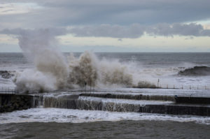
South-east England is set to be hit by an 80mph storm , dubbed Storm Angus, heading to Dover and London Tonight
The Met Office has issued an amber warning ahead of the storm coming from Bournemouth on Saturday night. “be prepared” warning before Storm Angus reaches the coast from Bournemouth to Dover overnight.
Forecasters have issued a yellow “be aware” warning for winds coming from Storm Angus of up to 55mph, with heavy rain expected in what ould create localised flooding.
Forecasters are warning of possible localising flooding. Met Office forecaster Simon Partridge, said there could be floods.
“It is the first storm of the season, coming quite late at this time in November,” said Mr Partridge. “This will be a bit of a shock to the system for most people in terms of wind and rainfall.
“Any weak branches are likely to come down in the first storm.”
Storm Angus is expected to reach the south-west of England at about 20:00 GMT on Saturday night, moving north-eastwards across the coast and up to East Anglia by Sunday morning.
Mr Partridge added that the storm is expected to move off quickly into the North Sea around midday on Sunday, leaving the rest of the day with dry sunny spells.
Northern parts of England will be colder with fairly light winds and clear skies. The Met’s office warning is a hint for people to avoid going out unless they really have to in the next couple of days.
Some parts of Yorkshire already have sprinklings of snow, with Scotland set to plummet as low as minus 10C (14F) overnight.
Speed restrictions will also be in place from 21:00 GMT on Saturday until 09:00 on Sunday, with a lot of rail track work underway on many rail stations on Sunday.


