
By Isabelle Wilson-
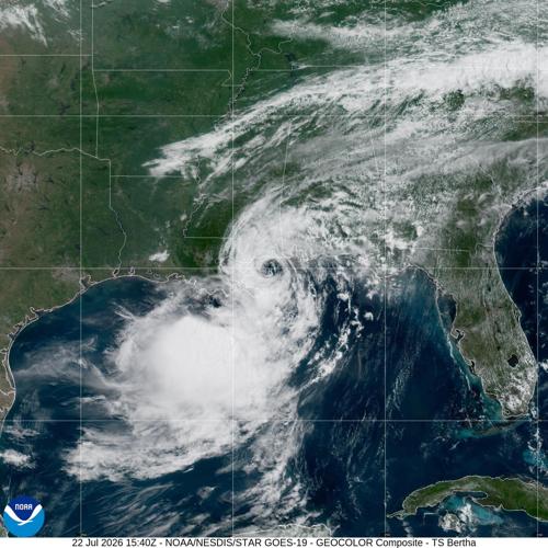
Tropical Storm Bertha made its second landfall along the Gulf Coast near the Texas-Louisiana border on Thursday, bringing heavy rain, coastal flooding risks and gusty winds to parts of the western Gulf region. The storm moved inland after first striking southeastern Louisiana, where it caused localised flooding and hazardous coastal conditions.
Bertha reached the Texas-Louisiana border area with maximum sustained winds of about 45 mph, according to weather officials. The storm’s center came ashore roughly northeast of Galveston, Texas, after moving westward along the Gulf Coast. Forecasters expected the system to weaken quickly after moving inland, eventually losing its tropical characteristics.

AD: Capeesh Restaurant
The storm developed in the Gulf of Mexico earlier in the week and became the second named storm of the Atlantic hurricane season. Although Bertha remained relatively weak compared with major hurricanes that have struck the Gulf Coast in past years, officials warned residents that tropical storms can still produce dangerous conditions, particularly through flooding, storm surge and strong winds.
Before reaching Texas, Bertha made its first landfall in Louisiana near St. Bernard Parish, southeast of New Orleans. The storm brought rough surf, coastal flooding and periods of heavy rainfall, while many of the strongest rain bands remained offshore over the Gulf waters. Beaches and coastal areas across parts of the northern Gulf Coast were placed under warnings as the system approached.
Emergency officials urged residents along vulnerable coastal communities to monitor forecasts and remain alert for changing conditions. Tropical storm warnings were issued along portions of the Gulf Coast stretching from Louisiana into Texas, reflecting concerns over possible tropical-storm-force winds and rising coastal waters. Despite the storm’s broad reach, early reports indicated limited damage.

AD: Oysterian Sea Food Restaurant And Bar
No deaths or major destruction were reported as Bertha crossed the Gulf Coast, although some areas experienced temporary flooding and storm-related disruptions. Officials continued assessing impacts as rainfall moved inland across parts of Texas and Louisiana.The biggest concerns surrounding Bertha centered on water rather than wind. Gulf Coast communities frequently face flooding threats during tropical storms because heavy rainfall can overwhelm drainage systems, while storm surge can push seawater into low-lying coastal areas.
Weather experts noted that Bertha’s structure limited the storm’s most intense impacts. Much of its rainfall stayed away from populated coastal areas, reducing the likelihood of widespread damage. However, isolated flooding remained possible, especially in locations affected by repeated rainfall or poor drainage.
In Texas, officials monitored conditions along the upper Gulf Coast as Tropical Storm Bertha moved inland. Areas near Galveston and surrounding coastal communities prepared for tropical-storm-force winds, heavy rain bands, dangerous surf and possible coastal flooding.The National Weather Service’s Houston/Galveston office issued tropical storm alerts for parts of the upper Texas coast, including Galveston-area communities, while forecasts showed Bertha would weaken as it moved farther inland after landfall.
The storm’s arrival highlighted the challenges Gulf Coast communities face during the Atlantic hurricane season, when even weaker tropical systems can create dangerous weather conditions. Emergency agencies have repeatedly emphasised that storm intensity is only one factor in determining risk, with rainfall totals, storm speed and location often playing a major role in potential damage.
Bertha also arrived during an active period of monitoring for tropical weather systems in the region. Meteorologists continued tracking the storm’s movement and advising residents to rely on official updates from weather agencies, including the National Hurricane Center and local emergency management offices. Bertha weakened after its second landfall, attention shifted toward cleanup efforts and continued monitoring of rainfall-related hazards. While the storm did not produce the catastrophic impacts associated with stronger Gulf hurricanes, officials stressed that preparedness remains essential throughout hurricane season.
While the center of Tropical Storm Bertha moved ashore near the Texas-Louisiana border, the storm’s influence extended across a much wider section of the Gulf Coast, affecting communities far from the exact point where it made landfall. Rain bands, coastal flooding risks, strong winds and dangerous marine conditions demonstrated how tropical systems can create hazards across multiple states even when they do not reach hurricane strength.
Residents along the Gulf Coast, the storm reinforced the importance of early preparation and continued awareness throughout the Atlantic hurricane season. Coastal communities in Texas and Louisiana have developed emergency plans based on years of experience with tropical weather, but each storm presents different challenges depending on its path, speed, rainfall amounts and intensity. A weaker tropical storm can still produce significant disruptions, particularly in low-lying areas vulnerable to flooding.
Officials continued monitoring weather forecasts after Bertha moved inland, watching for any remaining rainfall threats and localised flooding concerns. Emergency management agencies across the region regularly encourage residents to maintain preparedness supplies, review evacuation plans and stay informed through official weather updates.These measures are designed not only for stronger hurricanes but also for fast-changing tropical systems that may intensify or shift direction with limited warning.
The storm also highlighted the growing role of accurate forecasting and public communication during severe weather events. Advances in satellite technology, computer modelling and storm tracking have improved the ability of meteorologists to provide earlier warnings, allowing communities more time to respond. Officials continue to stress that forecasts can change quickly, particularly when storms interact with warm Gulf waters and shifting atmospheric conditions.
Along the Gulf Coast, preparedness remains a year-round responsibility. Cities, counties and emergency agencies are reported to be continuing a reviewing infrastructure, with drainage systems and response plans working stedfastly to reduce the effects of future storms. Coastal areas face recurring risks from storm surge, heavy rainfall and rising sea levels, making long-term planning increasingly important for protecting residents and businesses.
Storm that remains below hurricane strength still bring dangerous flooding, power disruptions and travel problems.Meteorologists have repeatedly warned that rainfall and flooding often pose greater threats than wind during many tropical systems, especially when storms slow down or move over heavily populated areas.
Gulf Coast communities are expected to remain alert for additional tropical activity. Officials will continue coordinating with weather agencies, emergency responders and local governments to prepare for potential storms that could pose greater threats in the months ahead.

AD: Heritage And Restaurant Lounge Bar